...
13 The CSV file is imported and Konect Manager automatically goes to the ‘Datasets’ item in the ‘Catalogue’ from where various data settings can be set, added or modified.
Append To An Existing Dataset
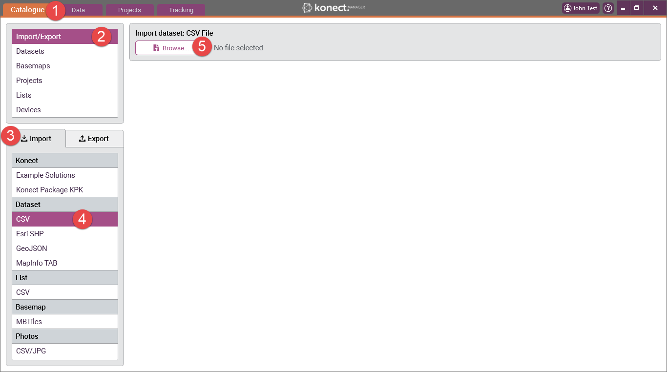
Use the following steps to append a dataset by importing a CSV file:
1 Go to the ‘Catalogue’ tab in Konect Manager.
2 Select ‘Import/Export’
3 Select the ‘Import’ tab.
4 Select ‘CSV' in the ‘Dataset’ list. NOTE: The CSV file must not be open in any other application for the import to proceed
5 Press the ‘Browse’ button. Select and 'Open' the required file. In this example ‘Bins.csv' has been used.
Where the CSV File HAS "X" and "Y" Coordinate Fields
6 If the CSV file has fields with the names "X" and "Y" and these fields contain valid longitude and latitude values respectively, Konect Manager reads the contents of the selected file and displays the number of records and the number of data fields in the file. It also draws a rectangle, called the bounding rectangle, that geographically encompasses all the map features in the file. You can use this information to check that the correct data is being imported.
Konect performs a comparison between the dataset being imported and all existing datasets in Konect. If the data structure matches in any way (at least one field) you will be presented with the option of either 'Creating a new dataset' or 'Appending to an existing dataset'.
If there is no match then you are only given the option of 'Creating a new dataset'
7 Select 'Append to existing dataset' from the options box
8 The dataset selection box will present. Choose the dataset you want to append to from the list
9 Select 'Append dataset'
10 A confirmation dialog will present. The warning information relates to potential difficulty that Konect may have in interpreting some data formats, in particular date and boolean (logical) data. Click 'Yes'.
11 The CSV file is imported and Konect Manager automatically goes to the ‘Datasets’ item in the ‘Catalogue’ from where various data settings can be set, added or modified.
Where the CSV File DOES NOT HAVE "X" and "Y" Coordinate Fields
6 If the CSV file does not have fields called "X" and "Y", Konect will prompt you to select the fields to be used. Any suitable numeric field will be available for selection from the pick lists. In this example there are only two possible choices and these just happened to be named "Latitude" and "Longitude" to make it easier to select the correct field.
7. Select the fields for Longitude and Latitude
8. Click 'Ok'
Konect Manager reads the contents of the selected file and displays the number of records and the number of data fields in the file. It also draws a rectangle, called the bounding rectangle, that geographically encompasses all the map features in the file. The user can use this information to check that the correct data is being imported.
Konect performs a comparison between the dataset being imported and all existing datasets in Konect. If the data structure matches in any way you will be presented with the option of either 'Creating a new dataset' or 'Appending to an existing dataset'.
If there is no match then you are only given the option of 'Creating a new dataset'
9 Select 'Append to existing dataset' from the options box
10 The dataset selection box will present. Choose the dataset you want to append to from the list
11 Select 'Append dataset'
12 A confirmation dialog will present. The warning information relates to potential difficulty that Konect may have in interpreting some data formats, in particular date and boolean (logical) data. Click 'Yes'.
13 The CSV file is appended and Konect Manager automatically goes to the ‘Datasets’ item in the ‘Catalogue’.


